Title: Understanding Lake Effect Snow Warning: What It Is, How It Works, and How to Stay Safe

What is a Lake Effect Snow Warning?
Lake effect snow warning is a weather term that refers to a specific kind of snowstorm that forms when cold, dry air moves over warmer lake waters. The phenomenon typically occurs near large bodies of freshwater such as the Great Lakes and other major lakes around the world. The warm waters of the lake provide moisture to the cold air, causing it to form snow clouds, which then dump heavy snow on the surrounding land areas. Unlike regular snowfall, lake effect snow tends to be localized, but it can be intense, making it important for residents in affected regions to stay alert.
Lake effect snow warning is issued by the National Weather Service when a snowstorm of this nature is expected to produce significant accumulations of snow. These warnings often come with specific instructions for how to prepare and stay safe during these heavy snowfalls, which can be both dangerous and disruptive. The warnings typically indicate that intense snowfalls may occur over a short period, leading to reduced visibility and hazardous travel conditions. It’s crucial to understand how to stay safe and what precautions to take during a lake-effect snow warning.

How Does Lake Effect Snow Develop?
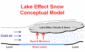
Lake effect snow occurs when cold air passes over the warmer waters of a lake, which is often still relatively warm compared to the air above it. This temperature difference causes the air to pick up moisture from the lake, and as it rises, it cools and condenses, forming snowflakes. The amount of snow that falls is directly related to the temperature of the water and the air, as well as the speed and direction of the wind.
When a cold air mass moves across a lake, the temperature difference between the water and the air can be quite significant. For instance, during the winter, lakes can remain warmer than the surrounding air, sometimes by as much as 10 to 20 degrees Fahrenheit. This significant difference creates a process called the “lake effect,” where the moisture from the lake gets drawn into the atmosphere, resulting in heavy snowfall when it cools and condenses.
This type of snowfall is not uniform and can be extremely localized. It often results in a narrow band of snow that can be only a few miles wide, yet it can produce very heavy snow within that band. It’s not unusual for one town to get only a few inches of snow, while another nearby town might experience over a foot of snow due to the same lake effect snow warning.
Key Features of Lake Effect Snow Warnings
Lake effect snow warnings are issued when a snowstorm is expected to bring significant snowfall in areas prone to this weather phenomenon. These warnings can be quite specific, focusing on smaller regions that will experience intense snow within a short period. Some key features of a lake-effect snow warning include the following:
- Heavy Snowfall: The most prominent feature of a lake effect snow warning is the heavy snow. This snow can accumulate rapidly, with several inches falling within a few hours. The snowflakes produced by lake effect storms are often large and wet, leading to quick accumulations that can make driving dangerous.
- Localized Snow Bands: One of the defining characteristics of lake effect snow is how localized it is. A band of intense snow can form, affecting only a small area, while the surrounding regions may see little to no snowfall at all. This localized snowfall can make forecasting tricky and requires constant monitoring to predict its movement.
- Wind and Visibility: Wind plays a crucial role in lake-effect snowstorms. Strong winds associated with the cold air mass can carry the snow, leading to blowing snow and drastically reduced visibility. This is especially dangerous for motorists, as sudden snow squalls can form and cause whiteout conditions with little warning.

The Impact of Lake Effect Snow on Local Communities
When a lake effect snow warning is issued, local communities in the affected areas are at risk of a range of impacts. These can include disrupted travel, power outages, and dangerous driving conditions. For residents who live in areas prone to lake-effect snow, preparation is key.
Travel Disruptions
One of the biggest impacts of lake effect snow warnings is on travel. The heavy and localized snowfalls can rapidly make roads hazardous, causing significant disruptions to both daily commutes and longer-distance travel. Local roads and highways in affected regions can become snow-covered quickly, and driving becomes treacherous, especially when visibility is poor.
For those living in areas that regularly experience lake effect snow, understanding the warning system and planning for these types of storms is essential. Keeping an eye on weather forecasts and having emergency supplies in your vehicle, such as blankets, food, and water, is a good idea during the winter months. Additionally, keeping your car in top condition, with proper tires and a full tank of gas, can help you stay safe when traveling in snowy conditions.
Power Outages and Infrastructure Damage
Heavy snowfall and strong winds often accompany lake-effect snow warnings, and the weight of the snow can damage trees and power lines, leading to power outages. While snow from lake effect storms may not last as long as other types of snowstorms, the intensity and localized nature of the snow can lead to significant infrastructure issues. Local governments and utility companies often work to prepare for these situations by clearing roads and ensuring that power lines are maintained. However, when an intense lake-effect snow warning is in effect, it’s wise to have backup plans, including flashlights, batteries, and a supply of bottled water.

Lake Effect Snow Safety Tips
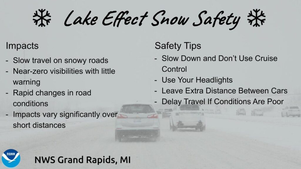
When a lake-effect snow warning is in effect, it’s crucial to stay informed and take steps to ensure your safety. The combination of snow, wind, and reduced visibility can make these storms unpredictable and dangerous. Below are several tips for staying safe during lake-effect snow events:
- Stay Informed: Keep an eye on local weather updates, either via television, radio, or weather apps. The intensity of lake effect snow can change rapidly, so it’s important to stay updated on the latest forecasts. Make sure to have an emergency weather alert system set up, so you’re notified when warnings or advisories are issued.
- Limit Travel: During a lake effect snow warning, it’s best to stay off the roads if possible. Snow can accumulate quickly, and driving conditions can change in a matter of minutes. If you absolutely must drive, make sure your vehicle is equipped for winter weather with proper tires, chains, and a full tank of gas.
- Clear Snow Immediately: As soon as it’s safe to do so, clear snow from your driveway and walkways. If you wait too long, the snow can become packed and harder to remove. Keep in mind that lake effect snow can often be wet and heavy, so use caution when shoveling to avoid injury.
How Meteorologists Predict Lake Effect Snow
Meteorologists use various tools and models to predict lake effect snow, including radar data, weather balloons, and satellite imagery. One of the challenges of predicting lake effect snow is its highly localized nature, which makes it difficult to pinpoint exactly where the heaviest snowfall will occur. However, modern weather technology has allowed for better forecasting, giving meteorologists the ability to issue lake-effect snow warnings ahead of time.
When a cold air mass moves over a lake, meteorologists track the temperature differences between the lake’s surface and the air above it. They also look at the direction and speed of the wind, as these factors play a role in determining where the snow will form. By combining data from these various sources, meteorologists can issue lake effect snow warnings that help communities prepare for the snowstorm.
Lake Effect Snow Across the United States
While lake effect snow is most commonly associated with the Great Lakes region, it can occur near any large body of water that is significantly warmer than the surrounding air. In the United States, areas around the Great Lakes, including parts of Michigan, Ohio, New York, and Pennsylvania, are particularly prone to lake-effect snow. These areas see some of the heaviest snowfall totals in the country, especially in regions like Buffalo, New York, and areas around Lake Michigan.
The snowstorms that form over these lakes can often be extreme, and lake effect snow warnings are issued frequently during the winter months. In these areas, lake-effect snow is an expected part of the winter season, and local governments have protocols in place for snow removal, road treatment, and emergency response. However, lake effect snow can also occur in more unusual places if the right weather conditions come together, so residents of other snow-prone areas need to understand the phenomenon.
Conclusion: Be Prepared and Stay Safe
Lake effect snow warning is a critical alert that helps communities prepare for the impact of this localized and intense weather phenomenon. By understanding how lake effect snow develops and how to stay safe during a warning, you can minimize the risks posed by these snowstorms. Whether you live in an area that frequently experiences lake-effect snow or are just visiting, it’s important to stay informed and take precautions when these warnings are issued. Always be sure to have an emergency kit, know your route, and check your vehicle’s condition before heading out during these unpredictable winter weather events.


